La Magdeleine

Edited by:
Massimo Martini
Access
La Magdeleine can be reached from the valley floor of the Aosta Valley by taking the motorway to the Châtillon–Saint-Vincent exit, from where you continue towards Valtournenche by taking the regional road . After approximately 7.6 km, you will reach Antey-Saint-André, where you turn onto the regional road towards La Magdeleine; the road climbs for a further 7.5 km to the main hamlet of Brengon. The municipality is not served by a direct rail link: the nearest station is Châtillon, on the Turin–Aosta line operated by Trenitalia (TI). Local public transport is provided by Savda, with services connecting the municipality with Antey-Saint-André and the valley floor; services are infrequent and subject to seasonal variations. During the winter months, it is advisable to check the conditions of the , which, in the event of heavy snowfall, may only be passable with snow chains or winter tyres. A covered car park is available near the parish church of Brengon.
Introduction
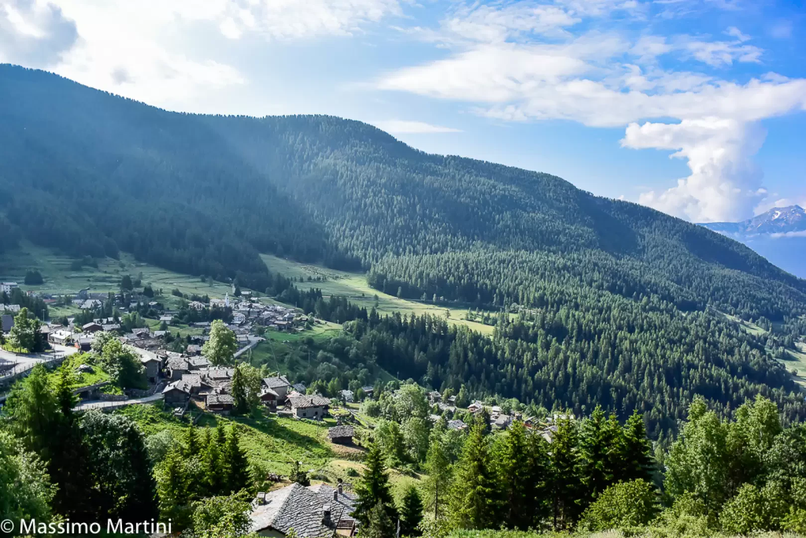
La Magdeleine is a municipality in Valtournenche, a right-hand side valley of the Aosta Valley, situated on the left bank of the Marmore stream at an altitude of 1,644 metres. The municipal area, which is relatively small, is entirely mountainous and comprises five historic hamlets — Artaz, Brengon, Clou, Messelod and Vieu — scattered along the hillside amongst coniferous forests and high-altitude pastures. It borders the municipalities of Antey-Saint-André, Ayas, Chamois and Châtillon. With just over a hundred residents, the municipality is one of the least populated in the Aosta Valley and forms part of the Unité des Communes valdôtaines Mont-Cervin.
Description
The territory of La Magdeleine covers a mountainous slope facing mainly west, with altitudes ranging from around 1,450 metres in the lower hamlets up to 2,734 metres at Monte Tantané, the highest point in the municipality. The landscape is characterised by an alternation of coniferous forests in the lower reaches and alpine pastures in the higher areas; in the alpine lakes of Champlong, the remains of large submerged conifer trunks can still be found, probably the last evidence of a vast forest cleared over the centuries to make way for hay meadows.
Human presence in the area has been documented since the Iron Age: excavations carried out at the foot of Mount Tantané have unearthed artefacts attributable to a permanent settlement of the Salasse people, with evidence suggesting a link to mining activities associated with the nearby gold deposit. In the Middle Ages, the village was known as Mont de Vieu and belonged to the lordship of Cly, which retained control until 1376, when Peter II of Cly was stripped of his fief by the House of Savoy. The lordship subsequently passed through various hands — including Cristoforo de Morales and Jean Fabri, Secretary of State — until it came into the possession of Pierre Philibert Roncas in the 17th century, a member of one of the most influential families in the Aosta Valley at that time. Ecclesiastical separation from Antey was granted in 1789, following a request first made as early as 1748 on the grounds of the distance from the main parish church, which was particularly problematic during the winter months; the independent parish was dedicated to Saint Mary Magdalene, the place name from which the present-day municipality takes its name.
The traditional economy was based on subsistence farming and the rearing of cattle and sheep. Families moved seasonally between the Châtillon plain, where they tended the vineyards in spring and autumn, and the La Magdeleine mountains, where they spent most of the year growing cereals and producing milk, butter and cheese. Woodworking was also widespread, with craftsmen making tools and everyday objects, including the characteristic ‘sabots’. Viticulture took place at altitudes between 550m and 850m and centred on the Petit Rouge grape variety, with some Gamay and Pinot Noir also grown. Among the local traditions, the ‘Bataille des Reines’ is worth noting: a competition between cows of the Valdostana breed, for which a regional championship has been held since 1957.
The municipality’s built heritage includes the Parish Church of Santa Maria Maddalena in Brengon, built in 1774 and subsequently altered in the nineteenth century, and two chapels: the Chapel of Saints Rocco and Sebastian in Messelod, founded in 1672 and featuring three devotional paintings on its façade, and the Chapel of Our Lady of the Snows in Vieu. Among the structures of historical interest, the eight watermills scattered across the hamlets of Brengon and Clou stand out; these are lined up along a stream and fed by a system of wooden channels known as ‘troccoli’. Dating back to at least the 18th century, they were used to grind wheat for black bread. Five of them have been restored and the route linking them is open to visitors, with access to the interiors available by booking. Also widespread throughout the area are the ‘rascards’, wooden structures traditionally used as haylofts, and the ‘greniers’, buildings for storing grain.
Due to its focus on sustainable transport, the municipality is a member of the Perle delle Alpi consortium. The local network of footpaths links up with the trails in the Valtournenche valley and provides access to the mountain pastures and the higher reaches of the area. Notable hiking options include routes along the ‘ru’ – ancient open-air irrigation channels that wind through woods and meadows – and winter snowshoe walks; the area also features a small ski lift serving the ski facilities.
Information
General information
Area: 8.94 km²
Altitude of the main town: 1,644 m
Highest point: 2,734 m – Mount Tantané
Population: 108 (as at 28 February 2026)
Name in dialect: La Madélène (in Aosta Valley patois)
Name of inhabitants: magdeleins
Patron saint: Saint Mary Magdalene (22 July)
Neighbouring municipalities: Antey-Saint-André – Ayas – Chamois– Châtillon
Province: –
Region: Aosta Valley
Country: Italy
Official website: https://www.comune.la-magdeleine.ao.it